
1. Project’s challenges
The Pyrenees, located between Atlantic Ocean and Mediterranean sea, is particularly representative of the main climatic challenges in the mountain areas. This territory presents a high degree of vulnerability especially with regard to biodiversity. The flora and vegetation of Pyrenees could be affected by climate changes with consequences for conservation of this exceptional heritage (species, natural and social environments, landscapes, ) and valorization of the resources they represent.
FLORAPYR program is the continuation, capitalization and consolidation of collaborations, sharing resources and results of biodiversity component of the Pyrenean Climate Change Observatory conducted from 2011 to 2014 (OPCC – EFA235/11).
Based on shared resources of Pyrenees Flora Atlas and Pyrenean snowbeds monitoring system, developed in previous program, FLORAPYR program develops new coherent actions to strengthen cross-border cooperation in Pyrenees with stakeholders in knowledge of floristic heritage of Pyrenees and in a transversal way with the partner organizations of OPCC.
FLORAPYR program will maintain, develop and make available knowledge of Pyrenean flora and vegetation, essential for studying the effects of climate change. It will also actively contribute to the production of indicators related to these evolutions thanks to different monitoring devices.
2. Project aims
Atlas flora of the Pyrenees constitute an updated database, available to all actors. It allows a better knowledge of the challenges and of the actions and monitorings to priorize, in relation with the conservation of the vascular flora. Its extension to other biological groups (bryophytes), as well as to vegetation catalog, will provide a solid basis for assessing and managing Pyrenean plant diversity. Objectives of the project are to improve functionality of atlas to facilitate access and use to different users (researchers, teachers, educators, environmental managers and the general public). To this purpose, it will offer new request possibilities (by territories, groups of species, periods, etc.) and allow visualization of different information layers through the OPCC web portal.
In addition, the snowbeds monitoring system, begun since 2011, will be strengthened and improved by collecting data to optimize the information obtained and increase its relevance. A simulation of warming effects (OTC) will be added. Satellite remote sensing monitoring of snowfields will be an original and innovative approach benefiting from the latest technologies. Participation in Gloria program will increase the interest of this device on Pyrenean scale and will contribute to international visibility of the OPCC.
The project aims new developments :
- A red list of Pyrenean vascular flora exemplary in Europe by a biogeographic and cross-border territory-wide approach, not restricted to political or administrative boundaries, more relevant for assessing extinction risks or to develop conservation policies, than arbitrary states or regions scales, because closely related to populations characteristics species distribution patterns throughout the chain;
- Involvement of a wider audience in data collection in order to inform about the possible climate change effects of on mountain flora, its phenomena and issues, in the Pyrenees.
3. Methodology
These objectives will be achieved through three main actions :
- Complete, synthesize, facilitate access to state of art of pyrenean flora and vegetation knowledge in order to put them in perpective with climate evolution;
- Define the main problems of plant diversity conservation, select priority species and communities for conservation and guide conservation policies coherent for the whole Pyrenees;
- Produce and complete monitoring indicators of pyrenean flora and vegetation in relation to the climate;
The project is based on the experience and results obtained by specialized institutions in their area of intervention. The mission framework of these institutions will enable them to maintain tools developed and to follow data management and monitoring protocols related to this project in longer term.
It also meets expectations of decision makers and to a wide public to access to a relevant and organized information on a scale of so an exceptional territory as the Pyrenees, which is an asset for long-term sustainability. The permanent plots for the monitoring of snowbeds, precisely localized and described, thus constitute irreplaceable reference states for future diachronic comparisons.
4. Results
The main expected results of the FLORAPYR program was the continuation of the cross-border cooperation, the exchange of experience, the coordination between the actors of the knowledge of the flora and the vegetation to produce usable and widely appropriable results at a Pyrenean scale. The FLORAPYR project has allowed maintaining and completing knowledge bases on Pyrenean flora, assessing the current situation of vascular flora and developing monitoring systems for the production of indicators.
Access to detailed flora datas and to Pyrenean floristic heritage synthetic datas
TWith this project, the atlas now collects more than 2.3 million data from more than 6,200 vascular plants (5068) and bryophytes (1182) in a renewed online interface that will facilitate its updating. The atlas has a file in Spanish and French that provides general and ecological information on each species, in addition to the distribution map. Synthesis layers can also be produced in the OPCC geoportal (10 x10 km of grid size for all flora and other indicators).
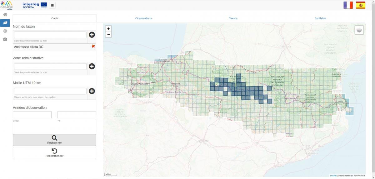
Distribution map of the Androsace ciliada (Androsace ciliata DC.), endemic to the Pyrenees.
The altitude vegetation catalog includes more than 170 types of vegetation, for each of which an explanatory sheet and a map of have been created. This catalog will serve as a basis for integrating more accurate data and alerting key conservation issues. The catalog can be consulted online at the website of the Atlas Pyrenean flora.
Production of tools for assessing threats and issues at the Pyrenean massif scale and its subterritories
This red list is used to assess the risk of species extinction. It has been possible to elaborate the scale list of the entire Pyrenean mountain range using the methodology of the International Union for the Conservation of Nature (IUCN). The situation of more than 4000 plants was examined by project experts and external experts to determine that just over 2% of the Pyrenees' flora is threatened. The greater or lesser vulnerability of these species to climatic variability depends on the scenarios of temperature evolution and the rainfall considered.
Photo: Chouard's Dioscorea (Borderea chouardii Gaussen), a critically endangered plant (CR) © M. Bernal
Production of monitoring indicators related to the climate
Desde 2011, este dispositivo ha permitido el seguimiento de estos hábitats singulares y especialmente sensibles desde un punto de vista climático. Gracias a la participación de 7 socios ha sido posible realizar el seguimiento de 14 sitios. Se ha mejorado el inventario de los 14 sitios, donde las observaciones se llevan a cabo cada año. Además, se han desplegado 4 dispositivos tipo “open top chamber” que permiten simular el efecto del aumento de las temperaturas en estos ecosistemas sensibles.
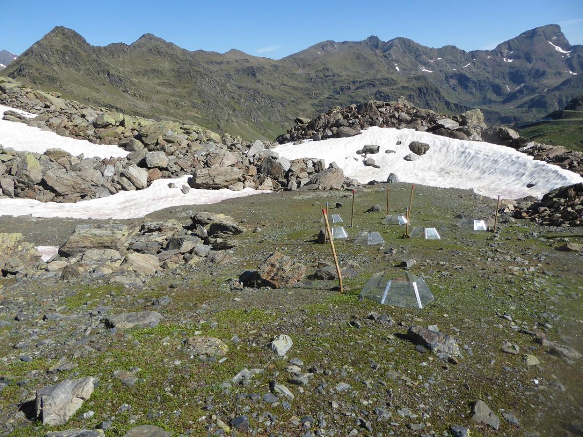
Photo: device Open top chamber in Andorra, © B. Komac / IEA-CENMA.
The international GLORIA (Global Observation Research Initiative In Alpine Environments) device for monitoring high mountain flora internationally, currently covers 100 mountain massifs worldwide. In addition to the two existing sites in Aragon, two additional locations have been created and consolidated in the French Pyrenees, with the support of the Fédération des réserves naturelles catalanes and the Parc national des Pyrénées.
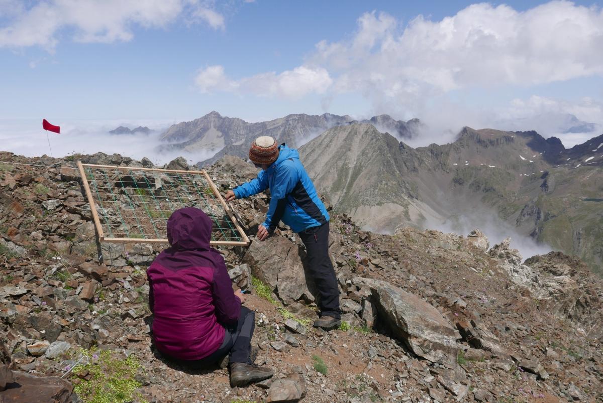
Photo: new GLORIA site in central Pyrenees © A. Reteau / CBNPMP.
Phénoclim is a scientific and educational program that invites the public to measure the impact of climate change on mountain vegetation through participatory observations of the phenological development (life cycle) of 13 target species. It has been deployed throughout the mountain range with the support of CREA Mont-Blanc and a dynamic animation of the Pyrenees Vivos education network, encouraged by the LPO. Currently, with this initiative, 42 observation zones are being followed.
Species distribution: evolution of the distribution of groups of sensitive species, developing layers in the OPCC2 geoportal.
Threatened flora: % and number of threatened or almost threatened species in the Pyrenees and layers in the OPCC2 geoportal.
Track monitoring: evolution of the floristic composition of habitats; evolution of the phenology of Salix herbacea and specific species; evolution of temperatures at the monitoring sites; evolution of the duration of the snow cover.
Phenology: phenological indexes of spring and autumn (Phénoclim Pyrenees).
Communication and ownership of issues by the public, including through participatory monitoring
This objective has been achieved in particular through participatory monitoring and participation in communication actions..
Conclusions
The complexity of the interactions between the different elements of global change makes it difficult to assess the direct effects of climate change on the Pyrenean flora. Data sets and series of observations long enough to be compared with climatic data are needed, especially for devices located at height. The work of the FLORAPYR project has allowed us to obtain preliminary data, but it is above all an essential basis for monitoring and analyzing the phenomenon of climate and global change in the medium and long term. There is a strong dynamic underway that partners wish to continue.
5. Project partners
| Partner | Corporate logo | Region / CCAA |
|---|---|---|
| Conservatoire botanique national des Pyrénées et de Midi-Pyrénées (CBNPMP) |
|
Occitanie / New Aquitaine |
| Conservatoire botanique national méditerranéen de Porquerolles (CBNMed) |
|
Occitanie |
| Instituto Botánico de Barcelona (IBB-CSIC) | Catalonia | |
|
Instituto Pirenaico de Ecología (IPE-CSIC), |
|
Other |
|
Aranzadi Zientzia Elkartea - Sociedad de Ciencias Aranzadi |
|
Gipuzkoa |
| Bazzania S.C., Investigación y Gestión en Biodiversidad |
|
Alava |
|
Universitat de Barcelona (UB) |
Catalonia |

| Associated Partner | Corporate logo | Region / CCAA |
|---|---|---|
| Institut d’Estudis Andorrans (IEA-CENMA) |
|
Andorra |
| Comunidad de Trabajo de los Pirineos |
|
Aragon |
| Organisations associées | ||
|
Consorci del Museu de Ciències Naturals de Barcelona |
|
Catalonia |
| Ligue pour la protection des oiseaux |
|
Other |
| Office national des Forêts |
|
Other |
| Nature en Occitanie ex Nature Midi-Pyrénées |
|
Occitania |


The project has been 65% cofinanced by the European Regional Development Fund (ERDF) through the Interreg V-A Spain France Andorra programme (POCTEFA 2014-2020). POCTEFA aims to reinforce the economic and social integration of the French–Spanish–Andorran border. Its support is focused on developing economic, social and environmental cross-border activities through joint strategies favouring sustainable territorial development.
update 5/11/2021


PYRENEAN CLIMATE CHANGE OBSERVATORY
Avenida Nuestra Señora de la Victoria, 8
22.700 - Jaca
Huesca - España
+34 974 36 31 00
info_opcc@ctp.org