CANOPEE - Climate monitoring maps and adaptive management in a changing climate
Description of the case study
Although change has not been the exception in the history of Pyrenean forests, but rather the norm, never have these changes happened at the current speed nor has man been so aware of them. For these reasons, the growing uncertainty around the climate, biological, and social environment in which future forests will be developed is widely recognised, and these questions are always relegated to a marginal position, specifically in the Pyrenean massif region.
Climate change may make forest multi-functionality difficult, in particular by causing the death and destruction of notable habitats and species. One of the CONOPEE project’s actions aims to assess the impact of different climate change scenarios on the monitoring that must be carried out on the Pyrenees region’s main forest species, insomuch as possible.
Likewise, through the design of forestry that is adapted to each situation, CANOPEE intends to promote the tenacity of masses or, lacking this, their non-traumatic evolution towards new forest formations that are more resistant and resilient to the new conditions in which they will continue to provide society with goods and services.
CANOPEE is considering the challenge of equipping regions and managers with the tools necessary to identify vulnerable areas and plan forest cover. In turn, this project intends to provide continuity in the monitoring of climate change impact indicators in woodlands, defined in the “Forest” (EFA235/11) action of the Pyrenean Climate Change Observatory (OPCC).
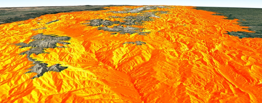
» Producing monitoring maps concerning the Pyrenees region’s key forest species.
» Applying a series of adaptive management operations to improve the resilience of at least 9 forest covers. This guide aims to share technical bases with the forest community to build an efficient adaptation strategy through demonstrative local actions that can modulate general recommendations. Before/after measurements have also been taken to identify the impact on water resource availability.
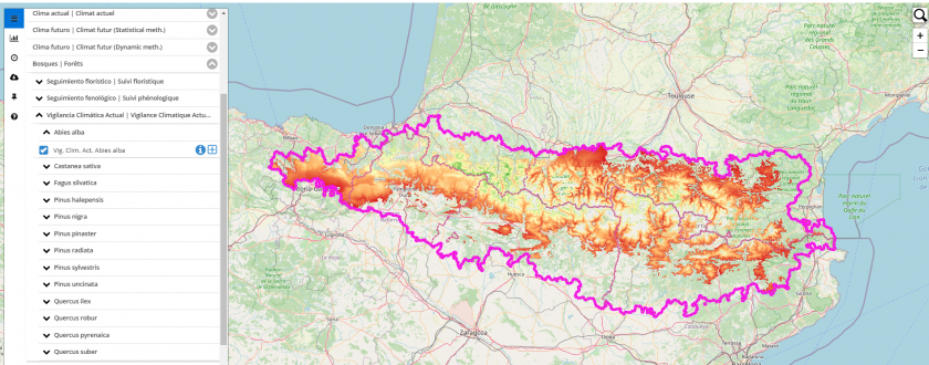
» More than 2,000 maps for different geographic entities have been produced. Content can be downloaded via the following links:
For the Pyrenees (CTP limits)
For Andorra
For Spain
Current Climate Monitoring maps (VCAs) for a series of woodlands have been obtained for statistical modelling. This indicator recommends different levels of monitoring for the populations studied based on whether the populations are located in a particularly dry or warm place compared to the entire Pyrenees region distribution area. Considering climate uncertainty and variability, low levels of monitoring do not guarantee the species’ survival, nor do high levels of monitoring determine the occurrence of a decline phenomenon.
» On the other hand, applying adaptive management guide operations has allowed the immediate impact on water resources available before/after the intervention (using the Medfate model) to be modelled for 12 forest covers.
The case study was developed and applied as a climate change adaptation measure.
FORESPIR, CPF, CTFC, CNPF, ONF, IPE-CSIC, HAZI FUNDAZIOA, IEA- CENMA, the Government of Aragon, OPCC-CTP
Additional Information
The project’s partners participated in all phases, specifically in methodological aspects.
Once the maps were produced, the opinion of field managers were requested in order to check the coherence of the observations made. This field assessment was also necessary in the application of adaptive forest management, in addition to the participation of research centres, public authorities, and private land forest managers.
The main limitation of these tools is focused on two key elements:
» The “uncertainty” factor around the climate change scenarios that will materialise.
» The “soil” factor. Although topography was taken into consideration insomuch as possible, it was not technically possible to take soil depth into account, which may have a limiting or aggravating effect on the water resources that will be available for stands.
Therefore, these tools are indicators that should be used in light of specific situations through land observations.
On the other hand, the ultimate impact of adaptive management operations will be measured in the long term (<10 years). As such, the lack of sustainability in financing is a major risk.
The project has been 65% co-financed by the European Regional Development Fund (ERDF) through the Interreg V-A Spain-France-Andorra programme (POCTEFA 2014-2020). POCTEFA’s aim is to reinforce the social and economic integration of the Spain-France-Andorra border region. Their assistance is focused on developing cross-border economic, social and environmental activities through joint strategies that favour sustainable regional development.
This action was carried out within the framework of the CANOPEE project, supported by POCTEFA, the Occitanie Region, and France through the FNADT.
01/06/2016 - 30/11/2019 (3 años - finalizado)
Reference information
PYRENEAN CLIMATE CHANGE OBSERVATORY
Avenida Nuestra Señora de la Victoria, 8
22.700 - Jaca
Huesca - España
+34 974 36 31 00
info_opcc@ctp.org


